Try It
Alabama's Forests Review
Part 1
Label the general physiographic regions of Alabama by identifying the proper physiographic region to the correct area on the state of Alabama map.
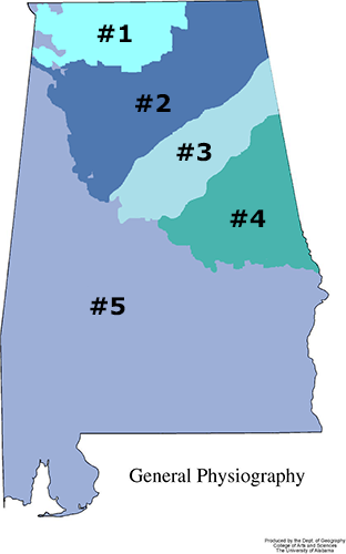
- What is the #1 physiographic region (bright blue area at the top, northeastern section of the state map)?
- Highland Rim
- Coastal Plain
- Cumberland Plateau
- Valley and Ridge
- Piedmont Upland
Answer: a. Highland Rim
- What is the #2 physiographic region (dark blue region in the northeast corner of the state and northern portion of the state map)?
- Highland Rim
- Coastal Plain
- Cumberland Plateau
- Valley and Ridge
- Piedmont Upland
Answer: c. Cumberland Plateau
- What is the #3 physiographic region (light blue area on the mid-eastern to northeastern section of the state map)?
- Highland Rim
- Coastal Plain
- Cumberland Plateau
- Valley and Ridge
- Piedmont Upland
Answer: d. Valley and Ridge
- What is the #4 physiographic region (the green area in the mid-eastern section of the state map)?
- Highland Rim
- Coastal Plain
- Cumberland Plateau
- Valley and Ridge
- Piedmont Upland
Answer: e. Piedmont Upland
- What is the #5 physiographic region (the blue portion that covers most of the state, specifically from the mid-western part of the state down to the entire southern area of the state to the coast)?
- Highland Rim
- Coastal Plain
- Cumberland Plateau
- Valley and Ridge
- Piedmont Upland
Answer: b. Coastal Plain
Part 2
Which of the 5 types of forest is each description depicting?
- I am very tolerant of cold temperatures, fire, and drought. I reside in the northernmost portion of the state. I am a hardwood. What type of forest am I?
- Long Leaf/Slash Pine Forest
- Oak/Gum/Cypress Forest
- Loblolly/Shortleaf Pine Forest
- Oak/Pine Forest
- Oak/Hickory Forest
Answer: e. Oak/Hickory Forest
- I am a mixture of hardwoods and softwoods. I lie between the hardwoods of the north, and the softwoods of the south. What type of forest am I?
- Long Leaf/Slash Pine Forest
- Oak/Gum/Cypress Forest
- Loblolly/Shortleaf Pine Forest
- Oak/Pine Forest
- Oak/Hickory Forest
Answer: d. Oak/Pine Forest
- I grow very quickly and consume most of the forestland in the state. I can withstand the heat of the climate, and the management tool of fire. What type of forest am I?
- Long Leaf/Slash Pine Forest
- Oak/Gum/Cypress Forest
- Loblolly/Shortleaf Pine Forest
- Oak/Pine Forest
- Oak/Hickory Forest
Answer: c. Loblolly/Shortleaf Pine Forest
- I like the beach like soil, very sandy. I live close to the ocean, and like the heat. I can also live through droughts. What type of forest am I?
- Long Leaf/Slash Pine Forest
- Oak/Gum/Cypress Forest
- Loblolly/Shortleaf Pine Forest
- Oak/Pine Forest
- Oak/Hickory Forest
Answer: a. Long Leaf/Slash Pine Forest
- I live in areas where there is a lot of water. I can live in areas where the soil does not drain very well. I am not as heat tolerant as the pines. What type of forest am I?
- Long Leaf/Slash Pine Forest
- Oak/Gum/Cypress Forest
- Loblolly/Shortleaf Pine Forest
- Oak/Pine Forest
- Oak/Hickory Forest
Answer: b. Oak/Gum/Cypress Forest