Introduction
Using a Grid
Did you know that flies inspired the creation of the coordinate plane? The idea of graphing with coordinate axes dates all the way back to Apollonius in the second century B.C. However, Rene Descartes, who lived in the 1600s, gets credit for coming up with the two-axis system we use today.
The story goes that Descartes was lying in bed watching flies crawling over tiles on the ceiling. He realized that he could describe a fly's position using the intersecting lines of the tiles. He created the x- and y-axis plane you're familiar with, and the system is often called the Cartesian coordinate system in his honor.
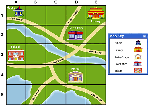
Grids help you locate places on maps. A grid uses lines to make rows and columns on a map. The rows go from side to side. On this map:
- The rows have a number to their left (The horizontal rows are numbered 1 through 5).
- The columns go from top to bottom. They have a letter at the top. (The vertical columns have letter names, A through E, going from left to right.)
- Every place on the map is in a single row and column. (Each location has a unique coordinate listing the row and column information. For example, the library's location is E1.)

Answer some questions about this map.
- This map has a grid to help you find different places. Every place on the map is in one of the squares. Which building is in square A3?
Answer: the school
- Where is the house? Name the square.
Answer: A1
- What buildings are in column D?
Answer: the post office (D2) and the police station (D4)
After you have explored how to use the coordinate system, continue on to the Learn section to get a better understanding of the entire coordinate plane.